Colorado Walkabouts

Hiking, Biking, Camping, Four wheeling

Chasm Lake

Published by Carl under on 8/01/2009 10:09:00 PM

When we pick a new trail to hike, I tend to prefer summits, while Stacie tends to prefer lakes.  This weekend we compromised by picking Chasm Lake.  This hike has lakes and waterfalls for Stacie, and it let me check out the first part of the Longs Peak Trail that I plan to use to summit later this month.

The Longs Peak trail is incredibly popular, primarily for the summit but also for the side destinations, like Chasm Lake.  Most serious summit hikers get started between 1 and 3 am, so it was no surprise when we pulled in to the trailhead at 7:30am that the parking lot was completely full, and cars were parked down the side of the road for half a mile.

We parked the Hummer at the end of the line of cars and hiked up to the trailhead.  That short walk

The trail started out fairly mild; it was smooth and wide, and not too steep.  The first 2 miles hike through the woods along Alpine Brook.  At the 2 mile point we reached the waterfall in the brook and crossed above it.

After crossing the waterfall we quickly got above tree line.  The views that had been teasing us between the trees were finally visible: Estes Cone to the north, Twin Sisters to the east, and the top of Longs Peak, Meeker and Lady Washington to the west.

The trail started getting steeper as we continued to ascend, with more rocks and steps to climb.  As we climbed up we saw a snowshoe hare who immediately hid in a bush on the side of the trail.

The last bit of the hike up to the saddle was very steep, almost all rock stairs straight up.  The saddle is a natural rest spot; it is large an open and the park service has installed a privy here.  There was even a group flying a couple of kites in the strong wind.  The trail splits here; straight ahead continues on to Chasm Lake while the right goes to the Boulderfield and the summit.

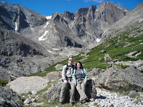
The view of Meeker and Longs Diamond was incredible, and we could see Ships Prow for the first time.  We stopped for a short break to appreciate the scenery and get our picture taken before continuing on the trail to Chasm Lake.

The trail continues along the south side of Mt Lady Washington, above a deep valley and the Roaring Fork Creek.  After a short while, Peacock Pool comes into view, and then Columbine Falls.

Peacock Pool is a unique little lake with bands of colors and an almost iridescent look.  Its appearance is constantly changing, but most of the time it really does look like the eye in a peacock feather.

Columbine Falls is a beautiful waterfall from the upper valley down into Peacock Pool.  It’s obvious how the falls got their name: on the right side of the trail there were dozens of columbine flowers, more than I’ve eve seen in a single place.

The trail wound around to the head of the falls, where we crossed Roaring Fork Creek and entered into a large alpine meadow bounded on three sides by huge cliffs of rock.  Our hike could have ended right here and we would have been satisfied; the views of Meeker and Longs towering over us were awe inspiring.

The trail continued to follow along the creek until we reached the ranger cabin at the base of the rocks.  Here the maintained trail ends, and it is a steep scramble up the rocks to finally get to Chasm Lake itself.

Chasm Lake sits just below the Diamond on Longs Peak east face. The lake is about half a mile (in vertical feet) below the summit.  We picked a spot on the east shore to take a break and eat our lunch.  It took us 4 hours to get all the way to the lake.  While we were eating I got out the binoculars to watch some technical rock climbers heading to the summit.  What looked like a tiny white dot to the naked eye resolved itself to be a climber ascending the 950ft face of the Diamond.

After lunch we packed up again and headed back down.  Despite being a repeat, the beauty of the scenery was still incredible, and we had a hard time turning our backs.  The descent was much easier than the climb up, and we made it down to the trailhead in 2.5 hours.

This hike really had it all: forest, tundra, streams, waterfalls, lakes, and mountains, plus the scenery was some of the best I’ve ever seen.  Seeing those massive peaks up close and dominating your view was indescribable.  I already feel that this hike is destined to be one of my all time favorites.

View all of the pictures: Photo Gallery

Read the rest of this post...

Mount Chapin

Published by Carl under on 7/25/2009 10:23:00 PM

This weekend we decided to attempt Chapin, Chiquita and Ypsilon.  These are part of a series of 12 and 13 thousand foot mountains in the Mummy Range in Rocky Mountain National Park.  Once you reach the first summit you can walk from peak to peak via the saddle between the mountains and keep going on down the range to as many other mountains as you wish.

We decided we were going to try for all three, but we figured that we would get at least the first one or two.  We got up at 6am on Sat to get an early start.  To get to the trailhead, we had to drive through RMNP to Endovalley in Horseshoe Park, and then take Fall River Road about 7 miles to the trailhead.  We got to the trailhead just after 9am, and the tiny parking area was full.  We had to park on the side of the road about a quarter mile farther up and hike back down to the trailhead.

The trail started out all business; the first 100 feet were at a 10% grade, and the first quarter mile was a constant climb, with grades up to 20% in a few spots.  It was also very technical, requiring us to constantly climb over roots and rocks.  We had to stop after the first tenth of a mile to catch our breath and put on bug spray; the mosquitoes were thick and aggressive in the woods.  We kept pushing on at a fast pace.


At about a quarter mile we hit the intersection where Chapin Creek Trail continues north and the summit trail goes east. We took the east (right) trail, of course.


The trail continued to be a steep climb for another quarter mile or so before it started to level out for longer stretches between the harder climbs.  We also started getting into larger meadows between the trees.

Looking ahead of us we could see a large, crumbling cliff with rocks and boulders spread out for a long distance downhill of it.  It almost looked like the summit, although we knew we were still too low.  The trail wound around to the left of it.


At one point there were several groups of blue columbine growing in the rocks right down the middle of the trail.  It was right in the middle of a particularly steep climb, so we were happy to stop and appreciate the flowers.

As we climbed through this section of the trail, we had a magnificent view to the west of Trail Ridge Road and the Alpine Visitor Center.  We could see exactly where we were just a couple weeks ago, climbing Marmot Point Trail.

After working our way around and up the right side of a hill we came to a split in the trail at about 0.7 miles.  The sign indicated that the right hand path was the route to the summits, and also warned us that the trails were no longer maintained past this point (“primitive” trails).  This is the end of the trail on the maps.

From this spot we got our first clear view of the Mummy Range from the trail. From right to left, we could see Mount Chapin, Mount Chiquita, Mount Ypsilon, Desolation Peaks, and Flatiron Mountain.

The end was in sight, but we still had a way to go.  We stopped for our first real break, and got out some energy gel to recharge after the previous 45 minutes of climbing and get ready for the next stage.

We took the right hand trail and traveled along the west flank of Chapin for another mile. It seemed like we were hiking right by Chapin, and at times the trail faded to where we could hardly see it, but we kept on going where we thought the trail was and found it again every time. Long fingers of talus stretched across the trail in many places, and the trail became more and more rocky as we went on.

This was the easiest part of the hike; we were still climbing, but it was a long, slow uphill grade instead of the steep climbs earlier.  Thankfully, this gave our legs a little bit of a rest.  We had pushed a little too hard on the first section of the trail, and by this point Stacie’s legs were burning with every step.  This stretch of trail gave her a chance to recover and let the lactic acid flush out of her muscles.  We also got to see many marmot and pika along the sides of the trail.

After about an hour of easy hiking we reached the crossroad in the saddle between Chapin and Chiquita.  Straight ahead was the trail to Chiquita, to the right was the trail to Chapin, and to the left was the alternate trail back to the earlier fork in the trail.  We took the trail to Chapin, which immediately started a super steep climb up the north side of Chapin.

As we climbed up we got our first view of the east face of Chiquita.  Unlike the smooth slope of the west face, the east face is a series of sheer cliffs and snow chutes. Of course pictures don’t capture it in the slightest; it was an awesome sight that dominated the northern view.

The east and north faces of Chapin are similar cliffs, and the trail to the summit runs along north edge.  After a short while up the 10 – 20% grades were were climbing, we needed another break, and we got out some more energy gel to fuel up for the final climb to the summit.


It didn’t take us long to get to the ridge line on the east side of Chapin,  At this point the trail, which was already almost invisible, faded no non-existence.  By this time the energy gel had kicked in full force, and we easily followed the ridge up to the summit.

We took our time exploring the summit, and stopped to eat lunch in the shelter of one of the stone lean-tos.  While we were eating a pika ran by right in front of us and took shelter in the rocks near our feet.

After we finished lunch we walked over to the south summit (12360 ft). At this point the wind was picking up, and the clouds were getting a little bit darker, so we decided we needed to head back down.  We quickly made our way back down to the crossroad in the saddle.  From there we decided to take the lower path back.

A short distance down the trail we started to feel raindrops, so we stopped to get out our rain jackets.  After a couple minutes it turned into a real rain, but luckily we had no lightning, and it only lasted for about 20 minutes.


The lower trail was extremely steep at the beginning, but then leveled out and took us down into the trees.  Unlike the higher tail, which was above tree line mostly rocks most of the way, this trail was in the trees and grass most of the way.  We didn’t have the incredible views of the higher trail, but we did see many wildflowers, including pink and red Indian Paintbrush.  Shortly after crossing a small creek (we saw the pond that fed it on the upper trail) we climbed up to the split where the upper and lower trail meet.

After a short break and some more gel it was straight on down back to the trailhead.  Our trekking poles once again proved their worth, saving our knees from the pounding of the steep trail on the way down. At the trailhead we had a short but steep hike up back up the road to where we parked the Hummer, and then a short drive the rest of the way up the road to the Alpine Visitor Center.

Mount Chapin was a short but surprisingly difficult hike, with highly technical and very steep ascents and descents.  It turned out to be one of the best hikes we have done to date, with incredible scenery the entire way and a rewarding summit at the end.

View all of the pictures: Photo Gallery

Read the rest of this post...

Fall River Road

Published by Carl under on 7/25/2009 09:31:00 PM

We drove up Fall River Road for the first time this weekend, heading to the Chapin Creek trailhead to do some hiking.  Fall River Road is the old route through RMNP before Trail Ridge Road was built.

The road starts at Endovalley, in Horseshoe Park.  Fall River Road is a narrow, winding dirt road; you cannot take RVs or trailers on it.  Because it is so narrow and there are so many blind corners the road is only one-way; you have to take Trail Ridge back down.  There are some curves so sharp that you have to stop and back up to get around if you don’t set it up correctly from the beginning.

Despite all of this (or perhaps because of it ) Fall River Road is a fun drive. We were able to comfortably go at about the 15mph speed limit in the Hummer, but many cars and SUVs were going much slower through the ruts and around the corners.  All of them were courteous enough to pull over in the wider spots to let us pass.

In the lower, forested section of the road we saw plenty of wildlife.  Several times we had to stop to get around groups of marmots in the road.  They appeared to be chewing on the rocks in the road for some reason.  At point we also saw a snowshoe hare bounding across the road.  They’re primarily nocturnal, so we were lucky to see one.  It had its full brown summer coat on.

Shortly before tree line we got the the Chapin Creek trailhead and parked to hike Mount Chapin.  When we got back we continues our trip up the road.

After we got above tree line we didn’t see any other animals, but the views of the surrounding peaks made up for it.

Once we made it up to the Alpine Visitor Center we turned out onto Trail Ridge Road and headed east toward home.  A little way down the road there was a group of elk causing a traffic jam from onlookers.  A park ranger was having to stand in the road and direct traffic to keep it moving.

We had originally planned to stop at Rock Cut and hike the short trail there, but it was mobbed with tourists so we kept on going.  As we headed down the road we got a few last glimpses of Mount Chapin and the Mummy Range before we left the park and headed home.

View all of the pictures: Photo Gallery

Read the rest of this post...

Coyote Ridge

Published by Carl under on 7/19/2009 07:45:00 PM

Stacie and I wanted to back off the difficulty a little bit on this weekend’s hike, so we visited a close by Fort Collins trail, Coyote Ridge.  The trail has lots of options for different difficulties and distances.

The trail started out in the prairie for the first half mile. Along the sides of the trail were numerous prairie dog colonies, with plenty prairie dogs running around.  The trail through this first section is wide and smooth, easily wide enough to walk side by side and still leave room for other hikers to pass.

We could easily see the first ridge all the way from the parking lot to the time we start climbing.  The first ridge looked like the smallest but still climbed 220 feet with an average grade of 5%. Once we got to the top the trail turned to the north and ran along the top of the ridge.

From the top of the ridge we had a great view of the plains to the east. Looking southeast we could see the city of Loveland and Lake Loveland.  After a short while we dropped down the back of the ridge and then slightly up again to the cabin and the nature loop.  There is a restroom here and the cabin makes a good place to take a break, with benches and shade.  We kept on going and started up the second ridge.

The second ridge wasn’t much of a climb; the trail curved around it to the north and gradually climbed up to the narrow gap between the second and third ridges. The second ridge never dropped down into a valley; it just leveled out for a very short distance and then started the third ridge right away.

The third ridge started around 1.7 miles, and it was the the most difficult climb. It was about half a mile long with an average grade of 8.5%, and there were several sections where the grade was 10 – 15%.   It was a tough climb, but we could feel the training we’d done on the rest of our hikes because we were able to hike straight to the top without stopping.

At the top of the ridge the trail turned south along the ridge line. This section was very short, and not that flat, but it did have the only real trees on the trail, and a few small sections of shade.

The back side of the third ridge was very steep, with grades up to 18%. We descended about 250 feet into a large meadow between the third and fourth ridges. The trail through the meadow was a nice break from the steep ups and downs of the ridges.

After we crossed the meadow the trail slowly climbed up the fourth ridge. The fourth ridge climbs 290 feet with an average grade of 7%.  It had been a hot day so far, but as we hiked up this ridge the breeze dropped off and the sweat really started rolling. There was no shade to take a break in so we kept on going.

When we finally got to the top of the fourth ridge we had to take a break for Stacie to get some blood sugar.  There was still no good place to stop we just sat down at the edge of a wider section of the trail for Stacie to have a few bites of an apple and some cheese crackers.  It was too hot to stop for very long, so we quickly got going again and finished the last bit of the Rimrock trail to the junction with the Blue Sky trail.

At this point we had hit our goal so we turned back.  The trip back down the fourth ridge wasn’t too bad, and crossing the meadow gave us a nice break before the climb backup the third ridge.  The climb up the third ridge was the hardest section of the hike, with constant 10 – 18% grades all the way to the top. We made it to the top without a break, but decided to stop at the top in the shade to take a food break and cool off a bit.

The clouds had been slowly building as we crossed the meadow, and by the time we started climbing down the third ridge there was a light cloud cover.  It was a relief to get out of the direct sun, and the rest of the trip back to the Hummer was a pleasant hike over the last couple ridges.

View all of the pictures: Photo Gallery

Trail Information:
Name: Coyote Ridge Trail / Rimrock Trail
Location: Between Loveland and Fort Collins on Taft Hill (Wilson) Rd
Length: 7.1 miles round trip 
Difficulty: Easy to Moderate
GPX file:
Elevation Profile:

Read the rest of this post...

Twin Sisters Mountain

Published by Carl under on 6/21/2009 11:03:00 PM

Stacie and I wanted to hike a little bit harder trail than we had been doing, so we picked Twin Sisters Mountain.  I wanted to get Stacie on a hike above tree line, and the guidebook said that the views were among the best of any hike along the front range.

Twin Sisters is located on the east side of Rocky Mountain National Park.  It is part of a detached section of the park on the other side of CO-7 from the main park.  The trail head is at the end of the road that leads back behind the Lily Lake Visitor Center.

We arrived at the trailhead parking area a little after 8am, and there were already enough cars that we had to park down the road a ways.  The actual trailhead is a quarter mile farther down the closed off road on the left side.

The trail starts off on a gentle grade but soon starts to climb.  A short way down the trail Stacie was really feeling the altitude, and we realized that she had forgotten to use her inhaler before we started.  She took a couple puffs right then, but it takes a while to fully take effect and open up her lungs.  We kept on going, taking our time, but as we worked our way up into the switchbacks Stacie was gasping for air and her heart was racing in the red zone.  After another hour the medication finally let her breath comfortably, but she burned a lot of energy during that first mile.

The view to the west from the switchbacks was one of the best views of Longs Peak I’ve ever seen.  We could see Longs Peak, Mt Meeker, Mt Lady Washington, and Estes Cone.

As we climbed up past 10,500 feet, the we noticed the trees starting to get thinner, and around 10,800 feet we got our first glimpses of alpine tundra in the large openings between the trees.  We started seeing snow on the sides of the trail, and the trees were really getting shorter.  There was also evidence of the strong winds; gusts of over 100mph are not unusual, and many of the trees were bent and twisted.


Finally at just over 11,000 feet we hit tree line.  The trail had been getting rockier up to this point, but after this it was all rocks with tiny patches of grass and moss along the sides.

From the tree line it’s only one more mile to the saddle, with just a few more switchbacks.

We made it up to the saddle between the two peaks at about 11:30am. There is a benchmark in the saddle to the east (left) of where the trail comes out.  To the west (right) is the Twin Sisters Electronic Site, a radio site used for search and rescue operations. From the saddle, you have to scramble up to the summit of each peak.  The west peak is quite a bit easier, but the east peak is taller, and it there was no one on it at the time, so after a short break we went east.

The scramble up the east summit is a steep, 60 foot ascent through broken rock with no defined trail.  The benchmark is toward the south side, at the highest point.  Slightly east of it is a log book in a white PVC container.  The spot where the log is located is a protected niche just big enough for two people and their packs.  We stopped there to enjoy a long lunch.  While we were relaxing we heard a pika alarming, and saw him run by just a few feet away.

The view from this summit is breathtaking; on a fairly clear day you can see east out to DIA; we could just make out the white roof of the terminal.  Looking west and slightly south Longs Peak dominates the skyline; there is no better view of the mountain than that.  Looking south, you can see down to Pikes Peak if you look carefully.  To the north and west you can see most of the Mummy Range.

Between the beautiful views, crisp air, and pleasant solitude we didn’t want to leave, but we knew there was a good change of afternoon storms so after an hour we started the hike back down.

As usual, the trip back down was almost harder than the hike up.  The constant pounding on the descent quickly tired out our feet and knees, and we stopped often for micro-breaks.  The switchbacks seemed to never end on the way down.

When we got back to the bottom it felt especially good to sit down in the Hummer.  Overall this was the most rewarding hike we have done to date, between the increased challenge and the incredibly rewarding views at the summit.

See all of the pictures: Photo Gallery

Trail Information:
Name: Twin Sisters Trail
Location: 10 miles south of Estes Park on CO-7, near Lily Lake
Length: 7.9 miles round trip 
Difficulty: Moderate
GPX file:
Elevation Profile:

Read the rest of this post...

Johnny Park Road

Published by Carl under on 6/05/2009 12:43:00 PM

On Fri afternoon Charles, Randy and I went out for our second LHN four wheeling trip.  Stacie came down to Boulder with Shy-Anne and met us at work, and then we grabbed some lunch and headed out to the trail.

Since Stacie and I had just been there hiking last weekend, I suggested Johnny Park Road.  Johnny Park Road is a fairly easy trail in Big Elk Meadows, near Pinewood Springs, CO.  We headed up CO-36 from Boulder and got there in about 30 minutes.  The sky was overcast, but it was a perfect temperature and we didn’t get any rain.

We started the trail on the optional spur south and east of the main trailhead.  On the way up to the trailhead, there is a small area on the left with room to park a couple vehicles and the start of CR-118.  This little segment adds about 1.6 miles to the trail and has some fun hills and rocks.

The first part of the trail basically travels up one long hill and then down the other side.  There are several steep, rocky uphill/downhill sections that are challenging and fun.  This was Randy’s first time out with us, but he got his stock F150 through every obstacle on the trail.

The first few rocks we found:

This was short, fun section going up a steep hill:

Some hill climbing:

Heading back down the steep hill toward the main trailhead:

After about an hour we finished the first section of the trail and got the to main trailhead.  We drove straight through and got started on the next section of the trail.  We each took a slightly different line on the first big hill, but we all made it up without problems.

After the first rocky hill we cruised around through Johnny Park itself and came around to the next big, rocky hill.  This looked like the most challenging one yet; near beginning of the hill there were some deep holes that needed rock stacking to get our trucks through, plus there were large steps the entire way up the hill.  At that point Charles was out of time so he was going to head back; Randy and I decided we’d try this hill next time and turned around with Charles.

Coming down was just as fun as driving up.  Here’s me coming back down the first rocky hill:

Here’s Randy coming down after me:

Once we got down to the trailhead we split up; Charles headed out to get to a soccer game while Randy, Stacie and I headed over to Randy’s house for a beer or two.

Our second monthly LHN four wheeling trip was another big success.  Randy is now hooked and already looking at ways to improve his truck on the trail, and all of us are back at work Monday counting the days until next time.

See all of the pictures: Photo Gallery

See all of the movies: Video Gallery

Read the TrailDamage.com description of Johnny Park Road: TrailDamage.com

Read the rest of this post...