Colorado Walkabouts

Hiking, Biking, Camping, Four wheeling

Devils Playground

Published by Carl under on 8/11/2009 11:44:00 PM

While we were in Colorado Springs we decided to do some hiking on Pikes Peak northwest slope.  The trail we picked starts at the Crags Campground (near Divide) and runs up to Devil’s Playground and the summit of Pikes Peak.

We got up at 5am, ate a quick breakfast and left the house at 5:45.  In the early morning fog I missed a turn on the way to the trailhead, wasting almost an hour, so we didn’t pull in to the parking area until just before 8am.  The trailhead was located at the far end of the Crags Campground, with a very small parking area and restroom.  We left the trailhead at 7:55 am at a chilly 41 degrees.

The trail to Devil’s Playground splits off from the Crags trail a few hundred yards down the trail.  The junction is easy to miss, but we had read the description before we left and knew what to look for.  The trail at this point was wide, not too rocky, and a nice gradual climb.  It was a perfect warm up for our cold muscles.

After the first half hour, we stopped to load up on energy.  We tried the Clif Shot Bloks this time.  We both liked them; they were easy to eat and tasted a little bit better than most energy gels.  After a short break we moved on up the trail.  By this time it had warmed up to 47 degrees, and the sun was high enough to give us some warmth in the open spots between the trees.

The forest growth was extremely thick through this part, and the trail was narrower; there were several times when my shoulders were brushing the branches on either side, or I had to duck under a tree/branch across the trail.  After another break for some gel around 9:30 we started getting into the transition between the sub-alpine forest and alpine tundra.  By 10:30 we were ready for some solid food, and Stacie’s left knee was giving her some pain, so we stopped for a break for some bars and ibuprofen.

As we got closer to tree line the trail got steeper.  The last mile leading up to tree line averaged an 18% grade.  After getting above tree line (around 11,900 feet) we had to climb a long, open hill side.  This half mile was brutal; it climbed straight up the hill for 800 vertical feet.  That’s a 24% grade – ouch.  It took us almost an hour to climb this stretch of trail, and we weren’t the only ones taking our time.

As we made our slow way up the hill, we had plenty of opportunities to enjoy the view to the west, and watch the ground squirrels running around on the rocks.  We also met a couple groups already on their way down from Devils’ Playground.

When we finally made it to the top of the hill we found ourselves in a huge saddle between several high points on the north flank of Pikes Peak, and we finally could see the summit.

We stopped for a break to recover from the climb, and I tried out my new tripod along with the timer on the camera to get a picture of the three of us:

We had originally planned to turn back just after Devil’s Playground (as soon as we reached 13,000 feet), but with the summit in sight we started talking about whether or not we could make it all the way.  We had started a bit late, and the weather was forecasting a chance of thunderstorms, but we were getting summit fever badly.  We decided to keep hiking on to 13k and see how it looked from there.

The trail at this point was a wide and smooth two track; it’s actually an old spur road that is no longer used. The trail winds around the valley, through a cut in the rocks and then into the dirt parking lot for Devil’s Playground. 

From the far side of the parking lot we could look down and see both Catamount Reservoirs and Rampart Reservoir.

We had reached Devil’s Playground, but we were still short of our goal of 13k feet, so we continued on.  We had to cross the road and step over a metal cable to get to the next segment of the trail; it parallels the road on the opposite side.

After about half a mile we joined up with the road at a lookout spot where a break in the mountains allows a view to the east.  For the first time we were able to look east and see down to Colorado Springs at the foot of the peak.  As we walked in to the lookout, the expressions on the faces of the tourists getting out of their cars was priceless.  Most of them could not believe that we had actually hiked up to here.

At this point we had already hit 13,100 ft, but we weren’t ready to head back down yet.  We continued on up the hill on the far side of the lookout point.  Part way up the hill, as we were taking a breather, I noticed I had service on my cell phone, so I called my parents to tell them we had made it to 13,000 feet (that was the highest cell phone call I’ve ever made!).

When we reached the saddle above the lookout, we could once again see the summit.

We had less than 2 miles to go to the summit, but we reluctantly decided not to continue on.  We had not planned on summiting that day, and we had accomplished our goal of getting above 13,000 feet.  With the uncertain weather forecast and already being late in the day we didn't want to rick thunderstorms, plus we wanted to have plenty of energy for descending the steepest parts of the trail. At 1:10 pm we turned back and started the hike back down.

When we got back to the cut in the strip of rocks on the other side of Devil’s Playground we stopped out of the wind for a longer break for “lunch” (bars and gels with plenty of water).  During our break we met a friendly pair of hikers who had already summited and were heading back down.

After our break we continued down and tackled the steep descent.  Even with trekking poles it was hard on our feet and knees, but we were able to make much better time on the way down.  We met a large group of Bay Scouts taking their time on the way up the hill.

Eventually we made it back to the trailhead a little before 4:30.  What took us just over 5 hours to ascent took us just over 3 hours to descend.  After relaxing for a little while at the trailhead we loaded up the Hummer and took off for home.

View all of the pictures: Photo Gallery

Read the rest of this post...

Medano Pass

Published by Carl under on 8/08/2009 10:26:00 AM

On Saturday morning Stacie and I drove up Medano Pass.  We were planning to do some four wheeling to get to the Medano Lake trailhead, hike to the lake, and then drive back down the pass.  Medano Pass Primitive Road starts right by the campground in the Great Sand Dunes National Park, and the first five miles travel north along the side of the dune field.  This stretch is very sandy and soft.  After that the trail climbs up into the Sangre de Cristo mountains, basically following Medano Creek.  The trail crosses the creek ten times before the top of the pass.  I had never driven in sand before, and I had limited experience driving through water, so it promised to be an exciting drive.

After breakfast I aired down the tires on the Hummer to 15psi and we headed out of our camp site.  The first stretch of the road was wide and easy; there was plenty of room to pull over and no deep sand to worry about.  There was a lot of traffic on this part of the road; it seemed like half the campers were taking their trucks and SUVs out for a drive.

After about a mile we got to the Point of No Return.  There is a small parking lot and a large sign warning inexperienced drivers of the conditions ahead.  One of the rangers told us that the minimum wrecker fee this year is actually $1500.  At this point the traffic dropped off sharply, and we didn't see another vehicle all through the sandy stretch.

As we passed the Point of No Return I picked up the speed a little bit to make sure I could maintain momentum and stay on top of the sand.  The sand got progressively softer as we went along; in some places the main tire tracks (where all of the vehicles had compressed the sand) were eight to ten inches deeper than the sand around them, and of course the sand under the tire tracks was practically bottomless.

At one point on the trail we went around a corner and saw another sign warning of extremely soft sand ahead.  This is where it really got fun.  There were still plenty of hills and sharp corners, which made it interesting as I tried to balance keeping my momentum up and slowing down for possible oncoming vehicles.  The trail in this section was just two deep tire tracks in the middle of soft sand, so there was no way I could have pulled over to get around another vehicle without getting stuck.  Luckily, we didn't meet any other vehicles so we were able to drive through without problems.

After a short while the sand got a little bit firmer again and the trail started heading more east into the mountains.  At this point the sand was still soft enough that I had to pay attention, but not enough to be a serious concern.  We did meet another SUV coming the other direction and we were both able to carefully go around each other in the softer sand at a wider spot on the trail.

Eventually the sand started giving way to forest as we approached the foothills.  The trail got quite a bit narrower but also easier; there were no significant rocks, sand, or any other obstacles other than the creek.


Right near the boundary of the park we came to the first creek crossing.  The bottom of the creek is made of small rocks and sand, so it was actually quite smooth to drive across.  The water was only about 10" deep, so it was no big deal.  At the end of summer like this the creek is usually pretty low.  In the spring time it can be 30" deep or more in this same spot.

The rest of the trail was just a fun drive through the woods.  The trail was basically smooth, with occasional small rocks.  There were sections where it got narrow between trees or large rocks where we had to slow down to squeeze through, but it was never very difficult, and we even saw a few full size trucks that had managed to scrape through.  About every 10 – 15 minutes we crossed the creek again.  As we got higher up the pass the creek got shallower, until it was only a couple inches deep (but still fun to drive through!).

At one point when we were following along the left side of the creek we saw a beaver dam and house:

Farther up the trail we saw the remnants of the old Herard homestead in a meadow on the left side of the trail.  This meadow is also know for the regular herds of Rocky Mountain Bighorn Sheep that frequent it, but we were disappointed not to see any on our way through.

Along the trail we had been seeing the backcountry primitive campsites that are available.  It was amazing to see the vehicles that people had brought up here; I think they must have come from the Westcliff side because there is no way the Subaru and Acura SUVs would have made it through the sand.  I'm amazed they were brave enough to take them through the creek crossings.


Shortly before our turn off, along the right side of the road I saw something in the grass that I couldn't quite identify.  When we got closer we realized that it was a flock of ptarmigan hiding in the tall grass.  As we continued up the trail we spotted other flocks several more times.


After about two hours of driving we got up to the left turn to the Medano Lake trailhead. At this point Shy-Anne was feeling a little sick so Stacie got out to walk her the last eighth of a mile.

When we got the the trailhead we got out and hiked the Medano Lake trail (read about our hike here).  When we got back, we relaxed in the Hummer for a while and then headed back down the pass.

The way back down was just like the way up, except that this time we saw more traffic heading up. At one point we even ran into a park ranger driving a full size Ford truck; I don't know how he managed to sqeeze through some of the tight spots without loosing his mirrors.

Although this is an easy trail for a 4x4 with good ground clearance, it's still not a trail for just any truck or SUV.  On the way back down we collected some pictures of lost parts from less prepared vehicles:

Overall this trail was great fun to drive, and I'm looking forward to going back. It wasn't very technically challenging at this time of year, but it was interesting and scenic enough to make up for it.  Down at the bottom of the pass you get some views of the north side of the sand dunes that you won't see any other way.

View all of the pictures: Photo Gallery

Read the rest of this post...

The Great Sand Dunes

Published by Carl under on 8/07/2009 06:20:00 AM

My parents invited us to go camping with them at the sand dunes in southern Colorado.  Neither of us had been down to the dunes in decades, and we’ve been wanting to go camping, so of course we took them up on their offer.  We decided to spend three days down at the dunes and then a couple days in Colorado Springs on the way back (to get in some extra hiking in the COS area).


We packed the Hummer with all of our gear on Thursday night.  I had just bought a new topper for the Hummer, and we filled it up.  This was our first camping trip in a couple years, so were trying to remember all of the little details that are second nature when you camp a lot.  We tend to be a bit over prepared, but we rarely need something we didn’t bring.

On Friday morning we got going. We decided to bring Shy-Anne with us and kennel the other two, so we dropped them off when the kennel opened at 8am and then hit the highway for the long drive south.

When we got to Colorado Springs, we stopped off at the north Wal-Mart to get some bottled water and load our cooler up with ice.  Since we were stopped, I decided to top up with gas, and while we were stopped Stacie decided we needed to stop in at REI to check out some sandals for the dunes.  After buying two pairs of sandals we figured we might as well get an early lunch since we had already spent so much down time.

Eventually we got back on the road and drove for several more hours to Walsenburg.  I topped off the tank again and then we drove west toward the dunes.

The Sangre de Cristo mountains are a really different look than the Front Range we are used too.  The mountains somehow seem steeper, more rugged, maybe due to their fault block formation vs. the Front Range uplift formation.

The route to the dunes goes west out of Walsenburg and through De Veta pass, crossing the Sangre de Cristos into the San Lous valley.  Along the way we got to see some impressive mountains, including Blanca Peak.

Eventually we turned north again, and after a while we got our first look at the dunes rising in front of us.

We finally arrived at the dunes and pulled in to the campground at 3pm.  My parents had gotten in a little before lunch time and gotten a spot on the south side of the lower loop.

After relaxing for a little while we decided to walk down to see the Point of No Return.  We took the dunes trail to Medano Pass Primitive Road and then walked down the road to the Point of No Return. 


When we got back to camp I set up our tent and we relaxed for a while before making dinner.  The wind picked up right before we started cooking, so we had a difficult time until Dad rigged up a wind screen with the boards out of the back of their truck.  It turned out that the wind would pick up every evening during the time we wanted to cook dinner, so we got a lot of use out of this little wind screen.

After dinner, Mom and Dad went down to the amphitheater for the evening’s program and Stacie and I took Shy-Anne for a hike on the dunes.

We set out for the dunes at about 7:45pm. The sun was already getting low, so we brought along our headlamps because we were planning on being out for several hours.

The dunes are deceptively far away from the camp ground.  They are so huge, dominating the horizon, that they seem to be just a short walk away.  In reality it was almost a mile before we started climbing up the first real dune.

Shy-Anne absolutely loved the dunes.  With her paws opened up as wide as possible she could run along the sand without sinking in. We, on the other hand, sunk in anywhere from two to six inches with every step.

The sky quickly faded from dusk to full dark, and the only light we had was from our headlamps.  The sand dunes are naturally sharp edged, and without the light from the sun every edge looked like a huge cliff.  Shy-Anne’s night vision was much sharper than ours, so she was constantly scaring us by jumping off these ‘cliffs’ and disappearing over the edge.  Every time it turned out she was just slightly downhill on the back side of the dune, but it still freaked us out every time.

By 9pm we had climbed up to the top of the first row of dunes (the ones you can see from the camp ground).  We had forgotten how difficult climbing the dunes really was, and it was a bit intimidating being out in full darkness, so we decided to turn back.

The trip back down was the real reason we climbed up to begin with; it’s incredible fun to run down the steep slopes.  You move fast and take huge strides; each step you sink deeply into the sand and it prevents you from loosing control and falling over.  We were able to run down some long 60 degree slopes, which in the darkness felt almost like free fall.  Of course, Shy-Anne loved it too, mainly because we were finally moving at here speed.

When we got back down to the bottom of the dunes we took our sandals off and enjoyed the last bit of warmth from the sand as we headed back to camp.

The next morning, we were up bright and early to a very chilly morning.  Mom cooked us an omelet and then we aired down the Hummer’s tires and headed up Medano Pass Primitive Road (read all about our four wheeling here).  Just before the top of the pass we turned off to the Medano Lake trailhead, where we parked and hiked Medano Lake Trail (read about our hike here).  We got back to the Hummer at about 3:30, and then drove on down the pass back to the dunes and camp.  We got back in to camp two hours later, just in time to make dinner.

After dinner the four of us went over to the amphitheater for the evening’s program, which was all about the horned and antlered animals in the Great Sand Dunes National Park.  We learned about the difference between horns and antlers and which animals of each type we might see in the park.  The ranger had an example of a horn/antler from each animal that he passed around so we could see and handle them.  We saw antlers from deer and elk, and horns from pronghorn (antelope), bison and big horn sheep.

After the program we went back to camp and started a campfire.  It was starting to get pretty chilly, and shortly after I started the fire the group of young college kids camping next to us asked to come over and warm up at the fire.  They only stayed for a short while, but we kept the fire going for a couple hours, and roasted hot dogs and marshmallows and made smores.

That night was very cold; it got down into the upper 30s in the early hours of the morning.  It was cold enough that Shy-Anne was shivering down on her bed, so we let her lay on top of our sleeping bag and put a blanket over her.

When we got up in the morning it was 43 degrees.  We got breakfast going as fast as possible so that we could enjoy some warm food.  After we ate, we packed up the camp.  I rolled up our sleeping bags, deflated the air mattress, took down the tent, and stored it all back in the Hummer.  That was followed by our cooler, food box, backpacks, and all of the junk that had accumulated in the cab over the last couple days.  Once we were all packed, we aired down the tires again and all four of us (plus Shy-Anne) got in the Hummer and went down to the Castle Creek picnic area.

We wanted to go to Castle Creek because Medano Creek was not flowing at part of the dunes closer to the camp site, and we really wanted to play in the water as well as the sand.  Castle Creek is past the Point of No Return and through a section of deep, soft sand, but we had driven it the day before so I knew what to expect and we made it without any drama.

When we arrived we did find water flowing, although it was only a couple inches deep. 


We had a lot of fun throwing Shy-Anne's ball for her to chase.

Stacie and I climbed up to the top of the short dune at the north end of the area where the creek takes a sharp curve.  From the top we had a great view of Mt Herard, and we saw some interesting tracks in the sand.  The back side of the dune was one the steepest one we saw all weekend (the farther north you go in the park the steeper the dunes are).  We ran down the back side of the dune and then went back to where my parents were waiting by walking through the stream.

When we got back we decided we had had enough fun and it was time to go.  We drove back to the campground for my parent's truck, and then headed out of the park.  On the way out we stopped at the visitor center to check out the exhibits and get one last view of the dunes.

View all of the pictures: Photo Gallery

Read the rest of this post...

Chasm Lake

Published by Carl under on 8/01/2009 10:09:00 PM

When we pick a new trail to hike, I tend to prefer summits, while Stacie tends to prefer lakes.  This weekend we compromised by picking Chasm Lake.  This hike has lakes and waterfalls for Stacie, and it let me check out the first part of the Longs Peak Trail that I plan to use to summit later this month.

The Longs Peak trail is incredibly popular, primarily for the summit but also for the side destinations, like Chasm Lake.  Most serious summit hikers get started between 1 and 3 am, so it was no surprise when we pulled in to the trailhead at 7:30am that the parking lot was completely full, and cars were parked down the side of the road for half a mile.

We parked the Hummer at the end of the line of cars and hiked up to the trailhead.  That short walk

The trail started out fairly mild; it was smooth and wide, and not too steep.  The first 2 miles hike through the woods along Alpine Brook.  At the 2 mile point we reached the waterfall in the brook and crossed above it.

After crossing the waterfall we quickly got above tree line.  The views that had been teasing us between the trees were finally visible: Estes Cone to the north, Twin Sisters to the east, and the top of Longs Peak, Meeker and Lady Washington to the west.

The trail started getting steeper as we continued to ascend, with more rocks and steps to climb.  As we climbed up we saw a snowshoe hare who immediately hid in a bush on the side of the trail.

The last bit of the hike up to the saddle was very steep, almost all rock stairs straight up.  The saddle is a natural rest spot; it is large an open and the park service has installed a privy here.  There was even a group flying a couple of kites in the strong wind.  The trail splits here; straight ahead continues on to Chasm Lake while the right goes to the Boulderfield and the summit.

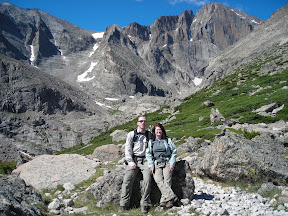
The view of Meeker and Longs Diamond was incredible, and we could see Ships Prow for the first time.  We stopped for a short break to appreciate the scenery and get our picture taken before continuing on the trail to Chasm Lake.

The trail continues along the south side of Mt Lady Washington, above a deep valley and the Roaring Fork Creek.  After a short while, Peacock Pool comes into view, and then Columbine Falls.

Peacock Pool is a unique little lake with bands of colors and an almost iridescent look.  Its appearance is constantly changing, but most of the time it really does look like the eye in a peacock feather.

Columbine Falls is a beautiful waterfall from the upper valley down into Peacock Pool.  It’s obvious how the falls got their name: on the right side of the trail there were dozens of columbine flowers, more than I’ve eve seen in a single place.

The trail wound around to the head of the falls, where we crossed Roaring Fork Creek and entered into a large alpine meadow bounded on three sides by huge cliffs of rock.  Our hike could have ended right here and we would have been satisfied; the views of Meeker and Longs towering over us were awe inspiring.

The trail continued to follow along the creek until we reached the ranger cabin at the base of the rocks.  Here the maintained trail ends, and it is a steep scramble up the rocks to finally get to Chasm Lake itself.

Chasm Lake sits just below the Diamond on Longs Peak east face. The lake is about half a mile (in vertical feet) below the summit.  We picked a spot on the east shore to take a break and eat our lunch.  It took us 4 hours to get all the way to the lake.  While we were eating I got out the binoculars to watch some technical rock climbers heading to the summit.  What looked like a tiny white dot to the naked eye resolved itself to be a climber ascending the 950ft face of the Diamond.

After lunch we packed up again and headed back down.  Despite being a repeat, the beauty of the scenery was still incredible, and we had a hard time turning our backs.  The descent was much easier than the climb up, and we made it down to the trailhead in 2.5 hours.

This hike really had it all: forest, tundra, streams, waterfalls, lakes, and mountains, plus the scenery was some of the best I’ve ever seen.  Seeing those massive peaks up close and dominating your view was indescribable.  I already feel that this hike is destined to be one of my all time favorites.

View all of the pictures: Photo Gallery

Read the rest of this post...