Pole Hill Road
Published by Carl under Four wheeling on 3/08/2009 11:27:00 PM Stacie and I went out for our first real four wheeling in the new Hummer. We chose Pole Hill Road because it is fairly close by and it's a pretty easy trail.
Pole Hill Rd is actually long road that goes from just outside of Estes Park all the way down to a couple miles west of Loveland, right near where we live in fact. The east end is also known as CR 18E, and we drive on it every time we leave our house and drive down into Loveland or up to Pinewood Lake. Unfortunately, a large part of the road is on private property and has been closed to public access for over 20 years. So much for our hope of driving up it all the way from our house to Estes Park! The open section of Pole Hill is only accessible from the end near Estes Park, off of Highway 36.
Getting to the trailhead is actually a pretty nice drive itself. You either go west on US-34 if you are coming from Loveland or farther north, or you go west on US-36/CO-66 if you are coming out of Boulder/Longmont or farther south. The trip up 34 winds through a canon along the Big Thompson River, whereas the trip up 36 takes you up through the foothills. Pole Hill road is located off of 36 just east of Estes Park.

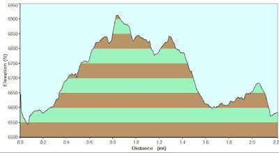
The first part of the road (just under a mile) is just a dirt road through a residential neighborhood, although it is the steepest non-trail road I have ever driven on (I can't believe people can get up it during the winter!). The actual trailhead is at the top of the residential section (1100 Pole Hill Rd).
The beginning of the trail is narrow and steep uphill. There are some mild off-camber sections that are hardly even noticeable unless there is snow on the trail. At the first rocky section I chickened out and took the bypass on the left side – maybe next time when I'm feeling a little more comfortable with the Hummer and we're not by ourselves.


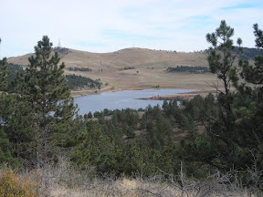
At the four way intersection (another half mile) we went right onto 247and followed it up and took a left on 247C. The trail drops down a hill into a meadow with another great view. This meadow can be muddy or even under water in the early spring – luckily it was dry for us.


The hill on the other side of the meadow is long and steep and has a few somewhat rocky sections. Eventually you come up to a sharp right corner and a locked gate. This is the point where 247C becomes 247 again. The gated trail is closed to motorized access, but it is open to hikers, and it leads all the way to Panorama Peak. We chose to continue around the right turn.
After a little while we came to a level, open spot where FS247A branches off to the left. It's yet another great panorama of the surrounding peaks, this time looking to the southwest.


We continued on FS247 all the way back to the four way intersection at FS122. At this point it was getting late in the day (we hadn't even started until mid afternoon) so we decided to take a left and head back. On the way back down the first steep section you get some more great views looking west.

We only spent a couple hours on the trail, but we had a great time and got a chance to get familiar with the Hummer off-road. Next time we'll do the entire trail and hit all of the harder lines.