Trail Ridge Road
Published by Carl under Driving on 5/23/2009 10:38:00 PM
We were itching to get up into the high country over Memorial Day weekend, but we wanted to avoid the crowds. I was especially excited about trying out the new hiking boots that I had picked up the day before. We decided to combine a drive and a hike by going to Rocky Mountain National Park and driving over Trail Ridge Road to the west side of the park. Once we got there we planned to take a hike and then drive back home.
The weather was iffy down in Loveland, but we decided to give it a try anyway. We loaded up the Hummer and headed to RMNP. Once we got in the gate we stopped in at the Beaver Meadows visitor center to buy a hiking guidebook and a map. While we were there Stacie decided to pick up a stuffed Pika; since we can’t bring our dogs with us to the park, he’ll be our companion on our adventures in RMNP.

After the visitor center we continued through the park to Fall River Road. Our original plan was to see if the road was open and take it up instead of Trail Ridge if we could. There is a trailhead several miles up the road we wanted to hit.
Unfortunately, we were grossly optimistic about Fall River Road being open; it’s typically buried under snow until much later in the season, and this year was no different (it’s scheduled to open in July). Instead, we drove back over to CO-34 and headed up the pass.
As we climbed, we started seeing large amounts of snow along the side of the road, but the driving conditions were still good. Once we got higher, however, we started to climb into the clouds and the fog across the road started getting thicker.


As we kept going, the fog got thicker, the snow got higher, and the temperature dropped. We had to slow down to about 25mph to see through the fog. It was a complete white-out around us, with visibility limited to about 60 feet; unfortunately we couldn’t see any of the scenery we had hoped to enjoy. There were several long sections where the snow on the side of the road ranged from 6 feet up to 14 feet deep, and the temperature was in the mid 30s. We had originally planned on stopping at the Alpine Visitor Center, but we came up on it in the fog to suddenly to turn in.


Finally, as we started down into the west side of the park we dropped below the clouds again and rediscovered the sunshine. The weather on the west side was quite a bit better than it had been on the east side of the park or even down in Loveland, although there was still plenty of snow.


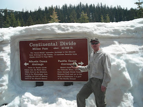
When we got to the continental divide of course we had to stop and take some pictures. By this time we were well into the sunshine and the temperature had warmed up by 20 degrees.


After the continental divide we continued a short while longer to the Colorado River trailhead. There is a large parking lot here and picnic tables as well as the trailhead, so we decided to park and have lunch before we started our hike.

After a light lunch we hiked for a while along the Colorado River (read about it here). After our hike we packed up and headed back over the pass. The fog was actually even thicker this time, with visibility down to 15 – 20 feet. It seemed to take forever to get back to the east side of the park, and we were very glad to be back out of it when we finally did.
Stacie’s hiking boots had gotten wet through to her socks by the end of the hike; they are low height, non-waterproof, lightweight boots made for summer hiking. On the way home we stopped in to Outdoor World in Estes Park to look at some waterproof, mid height boots for her to use during the spring hiking season. We ended up selecting another pair of Merrell boots for her. We then stopped in at the book store and picked up a couple more guide books for RMNP and northern Colorado hikes. These will help us achieve our goal of getting out hiking every single weekend this summer!
See all of the pictures: Gallery
0 comments:
Post a Comment