Colorado Walkabouts

Hiking, Biking, Camping, Four wheeling

Trail Ridge Road

Published by Carl under on 5/23/2009 10:38:00 PM

We were itching to get up into the high country over Memorial Day weekend, but we wanted to avoid the crowds.  I was especially excited about trying out the new hiking boots that I had picked up the day before.  We decided to combine a drive and a hike by going to Rocky Mountain National Park and driving over Trail Ridge Road to the west side of the park.  Once we got there we planned to take a hike and then drive back home.

The weather was iffy down in Loveland, but we decided to give it a try anyway.  We loaded up the Hummer and headed to RMNP.  Once we got in the gate we stopped in at the Beaver Meadows visitor center to buy a hiking guidebook and a map.  While we were there Stacie decided to pick up a stuffed Pika; since we can’t bring our dogs with us to the park, he’ll be our companion on our adventures in RMNP.

After the visitor center we continued through the park to Fall River Road.  Our original plan was to see if the road was open and take it up instead of Trail Ridge if we could.  There is a trailhead several miles up the road we wanted to hit.

Unfortunately, we were grossly optimistic about Fall River Road being open; it’s typically buried under snow until much later in the season, and this year was no different (it’s scheduled to open in July).  Instead, we drove back over to CO-34 and headed up the pass.

As we climbed, we started seeing large amounts of snow along the side of the road, but the driving conditions were still good.  Once we got higher, however, we started to climb into the clouds and the fog across the road started getting thicker.

As we kept going, the fog got thicker, the snow got higher, and the temperature dropped.  We had to slow down to about 25mph to see through the fog.  It was a complete white-out around us, with visibility limited to about 60 feet; unfortunately we couldn’t see any of the scenery we had hoped to enjoy.  There were several long sections where the snow on the side of the road ranged from 6 feet up to 14 feet deep, and the temperature was in the mid 30s.  We had originally planned on stopping at the Alpine Visitor Center, but we came up on it in the fog to suddenly to turn in.

Finally, as we started down into the west side of the park we dropped below the clouds again and rediscovered the sunshine.  The weather on the west side was quite a bit better than it had been on the east side of the park or even down in Loveland, although there was still plenty of snow.

When we got to the continental divide of course we had to stop and take some pictures.  By this time we were well into the sunshine and the temperature had warmed up by 20 degrees.
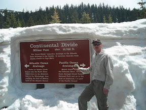
After the continental divide we continued a short while longer to the Colorado River trailhead.  There is a large parking lot here and picnic tables as well as the trailhead, so we decided to park and have lunch before we started our hike.

After a light lunch we hiked for a while along the Colorado River (read about it here). After our hike we packed up and headed back over the pass.  The fog was actually even thicker this time, with visibility down to 15 – 20 feet.  It seemed to take forever to get back to the east side of the park, and we were very glad to be back out of it when we finally did.

Stacie’s hiking boots had gotten wet through to her socks by the end of the hike; they are low height, non-waterproof, lightweight boots made for summer hiking.  On the way home we stopped in to Outdoor World in Estes Park to look at some waterproof, mid height boots for her to use during the spring hiking season.  We ended up selecting another pair of Merrell boots for her.  We then stopped in at the book store and picked up a couple more guide books for RMNP and northern Colorado hikes.  These will help us achieve our goal of getting out hiking every single weekend this summer!

See all of the pictures: Gallery

Read the rest of this post...

Fern Lake Trail

Published by Carl under on 5/17/2009 11:13:00 PM

During our day in Rocky Mountain National Park with Jenny and Wes we took a short hike along the Fern Lake trail.

We parked at the first parking lot that we thought was the trailhead (the one with the bathrooms).  In reality, the trailhead is another three quarters of a mile down the road.  This ended up adding an extra mile and a half (round trip) to our hike!  However, we did see run into a nice fellow hiker who took this group shot of us.

Once we finally got to the trailhead we started the real hike.  The first couple miles of this trail are easy as the trail follows the Big Thompson River and doesn’t climb too fast.

The trail scenery all along this section is beautiful.  There is the river constantly on the left side, views of various peaks also on the left, and an interesting rock face on the right side.  In several places we saw waterfalls on the right side from the spring run-off, and what looked like tailings from an old mine.

The trail was mild enough to make conversation easy, so we had a good time catching up with Jenny and Wes, as well as catching them in a couple of interesting shots:

By the time we got about a mile down the trail it was getting late in the afternoon so we had to turn back, and once we got back to the trailhead we still had another three quarter mile walk back to the car.  Along this final stretch my feet were hurting far more than they should have after such a short hike, so I finally decided it was time for some new boots and made a note to shop around next week during the Memorial Day sales.  Once we got back to the car we drove out of the park and dropped Jenny and Wes back at their car in Estes Pak and then headed home.

See all of the pictures: Gallery

Read the rest of this post...

Searching for Elk in Rocky Mountain National Park

Published by Carl under on 5/17/2009 10:39:00 PM

On Sat Stacie and I met Jenny and Wes up in Estes Park.  Jenny wanted to see some elk, so we drove up into Rocky Mountain National Park to find some.  On the way in Stacie and I bought a “National Parks and Federal Recreational Lands Annual Pass” – it gives us access to any federally operated recreation site across the country for one year.  That’s all of the national parks, federal recreation lands, open space, etc.

We entered the park through the Beaver Meadow entrance and headed straight to Moraine Park (left onto Bear Lake road, right onto Campground Rd, left on Fern Lake Rd).  Since Stacie used to work in and around RMNP and Estes Park she knew exactly where to take us.

Shortly after we entered the moraine we saw our first group of elk off close by on the right side of the road, and another in the distance on the left.

The scenery in the moraine is fantastic; you are in a large, level area surrounded by mountain peaks.

We drove down to the end of Fern Lake Rd to the Fern Lake trailhead.  Read about our hike here.  Once we were finished hiking, we drive back and saw even more elk than on the way down.  They were right up next to the road in several spots.

On the way out of the park, we drove around a little bit more to see if we could find some more elk or even bighorn sheep.  We did find another huge herd of elk in Horseshoe Park and sat for a while as they crossed the road.

We had a great time hanging out with Jenny and Wes.  Plus, the weather was perfect and the scenery was incredible; we can’t wait to go back to RMNP!

See all of the pictures here: Photo Album

Read the rest of this post...

Loveland Recreation Trail

Published by Carl under on 5/16/2009 08:43:00 PM

Stacie and I were originally planning to go four wheeling today, but it turns out most of the trails near by are still closed for the winter season (we’ve had a lot of late season snow up in the high country this year). We ended up doing a little “urban hiking” instead.

The Loveland Recreation Trail is a paved, urban trail that makes an almost complete loop around Loveland. The trail currently totals ~15.5 miles, and another ~5 miles are planned to complete the loop around Loveland. Go here for more information about the Recreation Trail System.

We drove down to Centennial Park (at Taft Ave and 1st Street) to start our hike.  The far east side of the parking lot is closest to the trail.  From anywhere in the park you can walk north and find the trail, but from the far east end there is a trailhead right off the parking lot.

The trail is a nice, easy walk along the bank of the Big Thompson River.  There are enough trees on both sides to provide a fair amount of shade for most of the trail.

The underpass for 1st Street has a large mural on the wall:

There are several places along the trail where you can get down the the river’s edge, if you wish.  We let Shy-Anne do a little wading at one spot.  She really wanted to go swimming, but I wanted her to be dry when we put her back in the Hummer.

One of the great things about this trail is that most of the time it is separated from the streets by open space, so it almost feels like you are out hiking outside the city.

Every quarter mile there is a marker at the side of the trail so that you can track how far you’ve gone.  We had gone a little bit less than a mile when we got to Barnes/Fairground park.  We walked through the park and then turned around and headed back to Centennial Park and the Hummer.

See all of the pictures: Photo Gallery

Trail Information:
Name: Recreation Trail
Location: Loveland, CO
Length: 2 miles (Centennial Park to Barnes Park and back)
Difficulty: Easy
Map: parks and trails map and bikeways map

Read the rest of this post...

Bunce School Road/Ironclads

Published by Carl under on 4/24/2009 11:27:00 PM

On Fri afternoon I went with Charles and Eric from work to go check out Bunce School Road.  Charles was our guide since he had done the trail before, and Eric was riding along.  Charles was driving his new 2009 JK Wrangler.  We are both still pretty new to our vehicles, have about the same amount of  off road experience, and our vehicles are similar in capabilities, so wheeling together is a lot of fun. 

As we drove up from Boulder it got noticeably cooler and we started seeing more and more snow along the side of the highway.

The north end of the trail starts at the historic Bunce School off of CO-7.  Most of the trail is pretty easy – we saw a stock late model Toyota 4 Runner and a mid 90s Ford F-250 coming down the trail.  There are a few rocky sections and hills to add some challenge, and on this day we had snow, water and mud as well.

A little ways down the trail we took an optional side trail to the left. This leg is almost all down hill, loosing about 340 feet of elevation down to highway 7.  It had some rocks and the only significant mud we ran into all day.  On the way back up we stopped to play on some rocks:

Shortly after that little side trip we got to the start of Ironclads trail (FS216).  Ironclads is a steep, rocky trail a bit more difficult than Bunce School Road. 


We got right to the first obstacle, a set of rocky steps. There is a bypass on the left side but neither of us took it.

As we continued on up the snow started getting deeper and drifting across the trail plus the trail started getting steeper.  We decided to turn around at the Y, just before the steep climb with with the 2 foot rock ledge.  That obstacle plus the deep snow and steep incline looked like it was a little bit beyond our current experience level.

On the way back down we ran into a park ranger who was curious how far up we had made it.  She actually gets paid to go four wheeling every day, traveling the trails to see if anyone is in trouble or breaking the rules.  What a life!

As we continued down Bunce School Road, the snow started to get deeper again, and the puddles on the trail started getting bigger and deeper.  Eventually the snow started drifting across the trail again, and we started slipping and sliding.  Since it was getting later in the afternoon and we had a ways to go we decided to turn around and head back.

Overall, Bunce School Road and Ironclads are a blast.  It's too bad we had a huge snow storm the week before, but we'll be back later in the summer when the snow's all melted and we can hit the entire trail.

See all of the pictures: Photo Gallery

See all of the movies: Video Gallery

Read the TrailDamage.com description of Bunce School Road: TrailDamage.com

Read the TrailDamage.com description of Ironclads: TrailDamage.com

Read the rest of this post...

Pole Hill Road

Published by Carl under on 3/08/2009 11:27:00 PM

Stacie and I went out for our first real four wheeling in the new Hummer.  We chose Pole Hill Road because it is fairly close by and it's a pretty easy trail.

Pole Hill Rd is actually long road that goes from just outside of Estes Park all the way down to a couple miles west of Loveland, right near where we live in fact.  The east end is also known as CR 18E, and we drive on it every time we leave our house and drive down into Loveland or up to Pinewood Lake.  Unfortunately, a large part of the road is on private property and has been closed to public access for over 20 years.  So much for our hope of driving up it all the way from our house to Estes Park! The open section of Pole Hill is only accessible from the end near Estes Park, off of Highway 36.

Getting to the trailhead is actually a pretty nice drive itself.  You either go west on US-34 if you are coming from Loveland or farther north, or you go west on US-36/CO-66 if you are coming out of Boulder/Longmont or farther south.  The trip up 34 winds through a canon along the Big Thompson River, whereas the trip up 36 takes you up through the foothills.  Pole Hill road is located off of 36 just east of Estes Park. 

The first part of the road (just under a mile) is just a dirt road through a residential neighborhood, although it is the steepest non-trail road I have ever driven on (I can't believe people can get up it during the winter!).  The actual trailhead is at the top of the residential section (1100 Pole Hill Rd).

The beginning of the trail is narrow and steep uphill.  There are some mild off-camber sections that are hardly even noticeable unless there is snow on the trail.  At the first rocky section I chickened out and took the bypass on the left side – maybe next time when I'm feeling a little more comfortable with the Hummer and we're not by ourselves.

After about half a mile we pulled off to the left and walked up a short side trail to an overlook with an awesome view of Estes Park and the surrounding mountains.  There's also a couple good camping spots here.

At the four way intersection (another half mile) we went right onto 247and followed it up and took a left on 247C.  The trail drops down a hill into a meadow with another great view.  This meadow can be muddy or even under water in the early spring – luckily it was dry for us.

The hill on the other side of the meadow is long and steep and has a few somewhat rocky sections. Eventually you come up to a sharp right corner and a locked gate.  This is the point where 247C becomes 247 again.  The gated trail is closed to motorized access, but it is open to hikers, and it leads all the way to Panorama Peak.  We chose to continue around the right turn.

After a little while we came to a level, open spot where FS247A branches off to the left.  It's yet another great panorama of the surrounding peaks, this time looking to the southwest.

We continued on FS247 all the way back to the four way intersection at FS122.  At this point it was getting late in the day (we hadn't even started until mid afternoon) so we decided to take a left and head back. On the way back down the first steep section you get some more great views looking west.

We only spent a couple hours on the trail, but we had a great time and got a chance to get familiar with the Hummer off-road. Next time we'll do the entire trail and hit all of the harder lines.

See all of the pictures...

Read the TrailDamage.com description...

Read the rest of this post...