Colorado Walkabouts

Hiking, Biking, Camping, Four wheeling

Deer Mountain

Published by Carl under on 5/25/2009 11:14:00 PM
On Memorial Day we decided to head up to Rocky Mountain National Park and try out our new boots by hiking the Deer Mountain trail.  Stacie has always wanted to hike to the summit. 

The weather wasn’t looking great, but we thought we would have enough of a window between storms to get to the summit and back.  As we were heading up to RMNP, we could see the clouds sitting over the mountains, but unlike the past couple days the ceiling was much higher.  We could actually see the mountains above tree line, and most of them we could see all the way to the top.

The trailhead is at the intersection of CO-36 and CO-34 in Rocky Mountain National Park.  When we got there at 11 am there was just enough parking for the Hummer.  We did have to park on the opposite side of the road, however.  It was a typically late start for us.

The first half mile of the trail was wide and easy, and it opened up into a meadow on the side of the mountain in a grove of aspens with a great view of the park.  We saw a number of casual hikers and tourists on this section of the trail.  Shortly after this section the trail got serious, and we started climbing through a serious of steep switchbacks.

The first few switchbacks were still climbing through the meadow with the aspens.  After that we were surrounded by pine trees most of the time, with occasional outlooks at each end of a switchback.

This section of the trail was challenging with our current conditioning, but we were regularly rewarded with views of the park.  Every once in a while we could catch a glimpse of the parking area down at the trailhead, so we could watch it get smaller and smaller as we climbed.

After the first two miles the trail finally leveled out a little bit and got easier again.  At this point we were on the large flat area between the individual peaks.  This easy section continued for almost a mile before we got the the intersection with the turnoff for the summit.


The final leg of the trail is a tough climb up a set of rock steps.  It’s only a tenth of a mile long, but you have to climb about 180 vertical feet.

When we finally made it to the top the views were breathtaking.  I just managed to snap a single picture of Estes Park from the summit when the camera died.  I had already used the extra batteries in the GPS on the way up, so we had to juggle batteries around to get a set that worked.  Finally we were able to get some pictures of us on the summit:

We were originally planning on easting lunch on the summit, but as were were finishing up taking pictures and enjoying the views it started to rain.  After a minute or two it started to hail as well.  At that point we quickly got out our rain gear and started heading back down.  There were several other groups of hikers just hitting the summit at that point, but we wanted to get back down out of the hail and possible lightning. By the time we got back down to the intersection it was back to just plain rain. 

As we retraced our steps back down the mountain it continued to rain off and on for the next couple of miles.  Part way down the switchbacks we stopped in the shelter of a tree to eat a couple bars from my pack to keep us going.  Eventually the rain let up and we finally made it back to the trailhead.  Once we got down we got out lunch and ate sitting on the side of the Beaver Meadows trail, across the road from the Deer Mountain trailhead.

Our new boots did great, and we brought enough layers to stay comfortable through the changing weather.  This was a fun trail and we got to check off a hike that Stacie has always wanted to complete.

See all of the pictures: Photo Gallery

Trail Information:
Name: Deer Mountain Trail
Location: Rocky Mountain National Park, CO
Length: 6 miles round trip (to the summit and back)
Difficulty: Moderate
GPX file: Download
Map:
Elevation Profile:

Read the rest of this post...

Colorado River Trail

Published by Carl under on 5/23/2009 11:13:00 PM

Since it was Memorial Day weekend we wanted to hit a trail in the western part of Rocky Mountain National Park to avoid the crowds on the east side.  We decided to try the Colorado River Trail that goes to LuLu City.  Once we made it over Trail Ridge Road we stopped at the Colorado River trailhead and had lunch (Go here to read about our trip through RMNP to get there).  After lunch we closed up the Hummer and hit the trail.

As the name implies, this trail runs along the east bank of the Colorado River.  The trail is a long, gradual downhill hike toward LuLu City.  The beginning of the trail was wide and smooth, with enough room to walk side by side.  We regularly ran into little streams from the spring run-off that we had to cross, as well as snow drifts across the trail.  Some of the streams had bridges across them, but most of them had to be jumped or waded across.  It was obvious that spring had only barely just arrived in the high country.

After a little while through the trees we got to a large meadow with an intersection.  We took the right path to stay on the same trail.  It started to rain just a little bit as we were crossing the meadow, but we decided to continue on.

The rain wasn’t so bad once we got back into the trees, but we continued to run into deep snow drifts and wide stream crossings.  Finally we hit a flooded section of the trail where a seasonal stream had filled in a low spot with several inches of water.  We had to carefully walk across on a log to keep Stacie’s feet from getting soaked (her hiking boots aren’t waterproof).  Once we got past that the trail improved a bit and moved down right onto the bank of the Colorado.

A short while later the trail moved east away from the river and into some thicker trees and a little bit more serious ups and downs.  The snow drifts really started covering the trail, but they were mostly packed enough to walk on.

When we finally cleared the trees and the snow again, we were able to see the cliff on our right and the tailings from the old mine.  This section also was home to several families of marmots.

Around this point the rain returned and we decided to head back.  On the way back we couldn’t help checking out the marmots again. As we headed back, the rain gradually got heavier and heavier, reinforcing the fact that we made the right decision.  Once we made it back to the Hummer we headed back for another white-knuckle drive over Trail Ridge Road and back home!


See all of the pictures: Gallery

Trail Information:
Name: Colorado River Trail / LuLu City Trail 
Location: Rocky Mountain National Park, CO
Length: 12.4 miles round trip (to LuLu City and back; we only hiked about 4 miles round trip)
Difficulty: Easy
GPX file: Download
Map:

Elevation Profile:

Read the rest of this post...

Trail Ridge Road

Published by Carl under on 5/23/2009 10:38:00 PM

We were itching to get up into the high country over Memorial Day weekend, but we wanted to avoid the crowds.  I was especially excited about trying out the new hiking boots that I had picked up the day before.  We decided to combine a drive and a hike by going to Rocky Mountain National Park and driving over Trail Ridge Road to the west side of the park.  Once we got there we planned to take a hike and then drive back home.

The weather was iffy down in Loveland, but we decided to give it a try anyway.  We loaded up the Hummer and headed to RMNP.  Once we got in the gate we stopped in at the Beaver Meadows visitor center to buy a hiking guidebook and a map.  While we were there Stacie decided to pick up a stuffed Pika; since we can’t bring our dogs with us to the park, he’ll be our companion on our adventures in RMNP.

After the visitor center we continued through the park to Fall River Road.  Our original plan was to see if the road was open and take it up instead of Trail Ridge if we could.  There is a trailhead several miles up the road we wanted to hit.

Unfortunately, we were grossly optimistic about Fall River Road being open; it’s typically buried under snow until much later in the season, and this year was no different (it’s scheduled to open in July).  Instead, we drove back over to CO-34 and headed up the pass.

As we climbed, we started seeing large amounts of snow along the side of the road, but the driving conditions were still good.  Once we got higher, however, we started to climb into the clouds and the fog across the road started getting thicker.

As we kept going, the fog got thicker, the snow got higher, and the temperature dropped.  We had to slow down to about 25mph to see through the fog.  It was a complete white-out around us, with visibility limited to about 60 feet; unfortunately we couldn’t see any of the scenery we had hoped to enjoy.  There were several long sections where the snow on the side of the road ranged from 6 feet up to 14 feet deep, and the temperature was in the mid 30s.  We had originally planned on stopping at the Alpine Visitor Center, but we came up on it in the fog to suddenly to turn in.

Finally, as we started down into the west side of the park we dropped below the clouds again and rediscovered the sunshine.  The weather on the west side was quite a bit better than it had been on the east side of the park or even down in Loveland, although there was still plenty of snow.

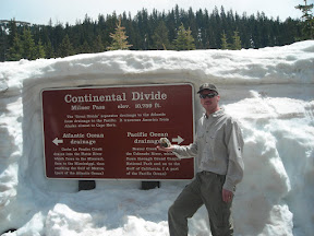
When we got to the continental divide of course we had to stop and take some pictures.  By this time we were well into the sunshine and the temperature had warmed up by 20 degrees.

After the continental divide we continued a short while longer to the Colorado River trailhead.  There is a large parking lot here and picnic tables as well as the trailhead, so we decided to park and have lunch before we started our hike.

After a light lunch we hiked for a while along the Colorado River (read about it here). After our hike we packed up and headed back over the pass.  The fog was actually even thicker this time, with visibility down to 15 – 20 feet.  It seemed to take forever to get back to the east side of the park, and we were very glad to be back out of it when we finally did.

Stacie’s hiking boots had gotten wet through to her socks by the end of the hike; they are low height, non-waterproof, lightweight boots made for summer hiking.  On the way home we stopped in to Outdoor World in Estes Park to look at some waterproof, mid height boots for her to use during the spring hiking season.  We ended up selecting another pair of Merrell boots for her.  We then stopped in at the book store and picked up a couple more guide books for RMNP and northern Colorado hikes.  These will help us achieve our goal of getting out hiking every single weekend this summer!

See all of the pictures: Gallery

Read the rest of this post...

Fern Lake Trail

Published by Carl under on 5/17/2009 11:13:00 PM

During our day in Rocky Mountain National Park with Jenny and Wes we took a short hike along the Fern Lake trail.

We parked at the first parking lot that we thought was the trailhead (the one with the bathrooms).  In reality, the trailhead is another three quarters of a mile down the road.  This ended up adding an extra mile and a half (round trip) to our hike!  However, we did see run into a nice fellow hiker who took this group shot of us.

Once we finally got to the trailhead we started the real hike.  The first couple miles of this trail are easy as the trail follows the Big Thompson River and doesn’t climb too fast.

The trail scenery all along this section is beautiful.  There is the river constantly on the left side, views of various peaks also on the left, and an interesting rock face on the right side.  In several places we saw waterfalls on the right side from the spring run-off, and what looked like tailings from an old mine.

The trail was mild enough to make conversation easy, so we had a good time catching up with Jenny and Wes, as well as catching them in a couple of interesting shots:

By the time we got about a mile down the trail it was getting late in the afternoon so we had to turn back, and once we got back to the trailhead we still had another three quarter mile walk back to the car.  Along this final stretch my feet were hurting far more than they should have after such a short hike, so I finally decided it was time for some new boots and made a note to shop around next week during the Memorial Day sales.  Once we got back to the car we drove out of the park and dropped Jenny and Wes back at their car in Estes Pak and then headed home.

See all of the pictures: Gallery

Read the rest of this post...

Searching for Elk in Rocky Mountain National Park

Published by Carl under on 5/17/2009 10:39:00 PM

On Sat Stacie and I met Jenny and Wes up in Estes Park.  Jenny wanted to see some elk, so we drove up into Rocky Mountain National Park to find some.  On the way in Stacie and I bought a “National Parks and Federal Recreational Lands Annual Pass” – it gives us access to any federally operated recreation site across the country for one year.  That’s all of the national parks, federal recreation lands, open space, etc.

We entered the park through the Beaver Meadow entrance and headed straight to Moraine Park (left onto Bear Lake road, right onto Campground Rd, left on Fern Lake Rd).  Since Stacie used to work in and around RMNP and Estes Park she knew exactly where to take us.

Shortly after we entered the moraine we saw our first group of elk off close by on the right side of the road, and another in the distance on the left.

The scenery in the moraine is fantastic; you are in a large, level area surrounded by mountain peaks.

We drove down to the end of Fern Lake Rd to the Fern Lake trailhead.  Read about our hike here.  Once we were finished hiking, we drive back and saw even more elk than on the way down.  They were right up next to the road in several spots.

On the way out of the park, we drove around a little bit more to see if we could find some more elk or even bighorn sheep.  We did find another huge herd of elk in Horseshoe Park and sat for a while as they crossed the road.

We had a great time hanging out with Jenny and Wes.  Plus, the weather was perfect and the scenery was incredible; we can’t wait to go back to RMNP!

See all of the pictures here: Photo Album

Read the rest of this post...

Loveland Recreation Trail

Published by Carl under on 5/16/2009 08:43:00 PM

Stacie and I were originally planning to go four wheeling today, but it turns out most of the trails near by are still closed for the winter season (we’ve had a lot of late season snow up in the high country this year). We ended up doing a little “urban hiking” instead.

The Loveland Recreation Trail is a paved, urban trail that makes an almost complete loop around Loveland. The trail currently totals ~15.5 miles, and another ~5 miles are planned to complete the loop around Loveland. Go here for more information about the Recreation Trail System.

We drove down to Centennial Park (at Taft Ave and 1st Street) to start our hike.  The far east side of the parking lot is closest to the trail.  From anywhere in the park you can walk north and find the trail, but from the far east end there is a trailhead right off the parking lot.

The trail is a nice, easy walk along the bank of the Big Thompson River.  There are enough trees on both sides to provide a fair amount of shade for most of the trail.

The underpass for 1st Street has a large mural on the wall:

There are several places along the trail where you can get down the the river’s edge, if you wish.  We let Shy-Anne do a little wading at one spot.  She really wanted to go swimming, but I wanted her to be dry when we put her back in the Hummer.

One of the great things about this trail is that most of the time it is separated from the streets by open space, so it almost feels like you are out hiking outside the city.

Every quarter mile there is a marker at the side of the trail so that you can track how far you’ve gone.  We had gone a little bit less than a mile when we got to Barnes/Fairground park.  We walked through the park and then turned around and headed back to Centennial Park and the Hummer.

See all of the pictures: Photo Gallery

Trail Information:
Name: Recreation Trail
Location: Loveland, CO
Length: 2 miles (Centennial Park to Barnes Park and back)
Difficulty: Easy
Map: parks and trails map and bikeways map

Read the rest of this post...